To contact us Click HERE
Alone with Hannibal, Kathleen has been getting alot done down in Buxton...spackling, sanding, sanding, maybe a little more sanding....then painting, painting...and painting some more. After she finished the downstairs washer/dryer closet, the plumber moved the washer/dryer in and hooked up both the wd and the vanity, so now the downstairs "works" (meaning all functions are operational). Her plan is to get the painting done and window blinds up, then she can move downstairs...and start the process all over again upstairs.
She took some pictures of her progress downstairs and posted them into the album "This Week's Progress".
30 Kasım 2012 Cuma
Kathleen's Week "Three": Finishing Touches
To contact us Click HERE
She uploaded some more pictures and making a good bit of progress! However, the longer she's there the more time she has to construct "to do" lists, one of which she sent me already. Hmmm, what "to do" about that? From a distance, not much i guess.
I just hope the length of her lists does not exceed our ability to complete the work. Her latest pictures are in the top slideshow.
I just hope the length of her lists does not exceed our ability to complete the work. Her latest pictures are in the top slideshow.
April 2011 1st installment of Easter week
To contact us Click HERE

It wasn't exactly the smoothest ride down, mainly because we stopped about 20 times trying to keep the tarps from blowing off the truck (first stop being on rte 44 about a mile from the house)...but a stop in Dover friday nite and a slow start saturday morning had us in Buxton by 6pm saturday. While unpacking, we actually had a couple from Richmond walk by and make the serious mistake of asking if they could help! During their tour we found out the carpet guy did get the carpet installed upstairs. Alot of beer later (i'm a little fuzzy on the time) we called it a day/night...the slideshow 1st Day Easter Week 2011 is where we are after the first day. My feet hurt.
It wasn't exactly the smoothest ride down, mainly because we stopped about 20 times trying to keep the tarps from blowing off the truck (first stop being on rte 44 about a mile from the house)...but a stop in Dover friday nite and a slow start saturday morning had us in Buxton by 6pm saturday. While unpacking, we actually had a couple from Richmond walk by and make the serious mistake of asking if they could help! During their tour we found out the carpet guy did get the carpet installed upstairs. Alot of beer later (i'm a little fuzzy on the time) we called it a day/night...the slideshow 1st Day Easter Week 2011 is where we are after the first day. My feet hurt.
Awesome website for 'post-Irene' imaging
To contact us Click HERE
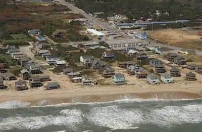 Check out this picture courtesy of USGS, taken after Irene on Wednesday 8-31-11.. Our friends at OBX Connections found this (thanks "twcmaster"): http://coastal.er.usgs.gov/hurricanes/irene/post-storm-photos/irene_photo.html
These are 3mb files that offer excellent resolution, just click on the orange dots up and down the coastline to view your neighborhood of interest! Our place "Stone's Throw" is almost in the middle of the picture, the square house with our silver truck in the driveway. For those unaware, if you're thinking about the obx for next year's vacation please check our mgmt company's website for both up and downstairs' units: http://www.hatterasvacations.com/
Check out this picture courtesy of USGS, taken after Irene on Wednesday 8-31-11.. Our friends at OBX Connections found this (thanks "twcmaster"): http://coastal.er.usgs.gov/hurricanes/irene/post-storm-photos/irene_photo.htmlThese are 3mb files that offer excellent resolution, just click on the orange dots up and down the coastline to view your neighborhood of interest! Our place "Stone's Throw" is almost in the middle of the picture, the square house with our silver truck in the driveway. For those unaware, if you're thinking about the obx for next year's vacation please check our mgmt company's website for both up and downstairs' units: http://www.hatterasvacations.com/
Guess who's moving to the beach?
To contact us Click HERE
 Kathleen Elizabeth! And she leaves for the beach Sunday, as she has enrolled in the NC Real Estate Class that starts Monday in Nags Head. Her plan is to work part time while taking the class (has an interview with Midgett Realty on Tuesday), and afterwards take the broker exam while working full time. Classes are MWF, 6pm-10:30pm. She'll stay at the beach house for the 2 months of classes. After that, well... she's even looking at travel trailers she can park in a campground. So away she goes, paving the road for us to follow. I'm betting she does just fine, which means i better figure out what i'm going to do down there. Maybe i'll learn how to fish.
Kathleen Elizabeth! And she leaves for the beach Sunday, as she has enrolled in the NC Real Estate Class that starts Monday in Nags Head. Her plan is to work part time while taking the class (has an interview with Midgett Realty on Tuesday), and afterwards take the broker exam while working full time. Classes are MWF, 6pm-10:30pm. She'll stay at the beach house for the 2 months of classes. After that, well... she's even looking at travel trailers she can park in a campground. So away she goes, paving the road for us to follow. I'm betting she does just fine, which means i better figure out what i'm going to do down there. Maybe i'll learn how to fish.
29 Kasım 2012 Perşembe
Hawaii's Grand Wailea Resort Hotel & Spa on Maui Completes $50 Million in Renovations
To contact us Click HERE
One of Hawaii's premier destinations, Grand Wailea Resort Hotel & Spa, a member of the Waldorf Astoria Collection, has announced the completion of more than $50 million in upgrades and renovations.
Featuring newly remodeled guest rooms, a refreshed spa and fitness center, updated restaurant and lounges, remodeled beach and pool, and up-to-the-minute technology upgrades across the resort, Grand Wailea's charm and founding elements of trees, water, flowers, art, light and sound more prominent and enjoyable than ever.
Find more Hawaii and Island information at http://www.thealohazone.net
Enjoy Valentine's Weekend on the Island of Bimini in the Bahamas
To contact us Click HERE
Bimini Sands Resort & Marina is pleased to offer this special Valentine's Weekend package designed to bring out the romance in your life. The Valentine's Weekend package includes luxury resort accommodations at Bimini Sands Resort & Marina, an elegant Valentine's dinner at the Beach Club Restaurant and complimentary breakfast each morning at the Petite Conch Cafe overlooking the marina. A scenic Sunset Island Boat Tour rounds out the perfect weekend in the islands.
At Bimini Sands there is always something to do. Stroll picturesque white sand beaches adjacent to the resort. Hike the Bimini Nature Trail set on 25 acres overlooking the Atlantic ocean. Kayak through remote mangroves and pristine flats. Snorkel the crystal clear waters that have made the island famous. All this and more awaits you at Bimini Sands Resort & Marina.
Find more Hawaii and Island information at http://www.thealohazone.net
Three More, Let's Make It Four
To contact us Click HERE
Smokies SB6K Backpack – Day Two – 6/9/12 – BalsamMountain/ Appalachian Trail/Off-Trail – 12 Miles
I got up once during the night for a nature call andrealized anew what a bad spot my tent was in. Getting out of the door required crawling uphill, and when I stood up inthe pitch dark I could not get my balance on the slope. Arms pinwheeling, I pitched forward into atree branch about neck high, which bounced me backward onto my butt, and then Irolled downhill back onto my tent. Thankgoodness I didn’t knock it down completely, it just sagged a little (okay, alot). After peeing, I crawled back inand vowed to die there rather than get up again in the dark.
The trail crew guys were up early making noise, which neverbothers me – I enjoy lying in my sleeping bag while other people are up. They left by 7:30 a.m. and I carefullycrawled uphill out of my tent again. Hadto wake Jeff up. We packed our stuff,ate a little something, and then explored the crew’s base of operations. We had a fun Goldilocks moment sittingin their chairs in the shelter – tee hee.
Packs on our backs and ready for three more SB6K’s, Jeff wasin front of me as we headed back to Balsam Mountain Trail. As Jeff stepped past, a brownish four-footsnake popped out from underneath the shelter and began its slinky sidewaysapproach down the path straight toward me. I began to yell, “Hey, hey, hey!” which to me meant “Snake, yikes, saveme!” and to Jeff meant absolutely nothing because he didn’t turn around(perhaps he thought I was singing?) Istopped on the path and the snake kept coming, until I stepped off to the rightand it slithered off to the left. Ididn’t make note of its markings because I was fascinated by its graceful glide.
 In the first half-mile we caught up with the trail crew,taking a quick break from their morning’s work improving Balsam Mountain Trail. With hazel hoes and rakes theyhad cut deeper into the bank and widened the trail. Ours were the first hiker footsteps on thisnew improvement.
Balsam Mountain Trail is one of the best trails in the parkthat few people ever see. From LaurelGap the trail takes a distinct left turn and runs along the ridge of BalsamMountain, acting as the horizontal bar of the letter “H” connecting the MountSterling ridge on one side and the AT ridge on the other. It’s an easy trail to walk on, not muchchange in elevation, with glimpses into the valleys on either side. The trail character alternates betweenhardwoods and alpine forest, rocks and roots and lush green ferns.
 Peaking through (notice the dark cloud looming above?)
 Balsam Mountain Trail #1
 Balsam Mountain Trail #2
 Balsam Mountain Trail #3
 Balsam Mountain Trail #4
 Bear print – we saw several of these, always headed in theopposite direction – I guess Mr. Bear was here yesterday?
 Dropping our packs to climb Luftee Knob
Although not a picnic, bush- whacking up to the summit ofLuftee Knob was not as difficult as Big Cataloochee yesterday. In retrospect, Big Cat was an excellent firstexperience to measure the other summits against. I didn’t like it, I was exhausted by it, butI survived it and felt that elation of accomplishment. I continually asked Jeff for a ranking of allthe other summits and a comparison to Big Cat. Why? I was going to do them nomatter what. But with any endeavor thechallenge is mostly mental, and it helped me to get psyched (or resigned) towhatever was coming up. Luftee Knob wasa .6-mile round trip, less steep but just as gnarly with lush undergrowth anddowned tree obstacles. There wasnothing to indicate the summit other than Jeff’s GPS said so.
 A couple of miles further along Balsam Mountain Trail wereached our next challenge, two summits originating from the same location onthe trail, one to the right and the other to the left. First, Mt. Yonaguska, which Jeff had notsummited. (Those funny SB6K guidelines say that either Mt. Yonaguska orTricorner Knob can count because they are the same height and are consideredspurs of each other – Jeff has bagged Tricorner Knob.) So up we went, the shortest trip yet at .25miles each way and Jeff creating a GPS track, to this scenic spot on top of Mt.Yonaguska.
(And how do you pronounce that? Yon-uh-GOO-skuh. Say it out loud now. Nobody is listening.)
 Coming back down, Jeff says “Follow me.”
 And I’m trying.
A little rest and something to eat while Jeff explains ournext summit to Mark’s Knob. This is 1.1miles one way, which I equate to multiple hours based on what we’ve experiencedso far. But…this used to be a maintainedtrail (decommissioned how many years ago?) going around Mt. Hardison and Mark's Knob and over to Hyatt Ridge Trail (which now dead ends at Campsite 44) and it’s relatively level, not muchelevation gain until the final push, and discernible where trail builders cutthe trail out of the mountainside and leveled it (just like the trail crew wasdoing when we passed them this morning – go back and look at that photo). AND several people had put up flagging tapethe whole way. I was thrilled.
 Summit of Mark’s Knob
 New growth on balsam branches
 One rather significant detail – unmain- tained means crews no longer clearthe deadfall on the trail. We were constantly stepping over, duckingunder or climbing over trees of all sizes. On the return leg we counted about 350 trees across the trail. Yes, that means that out-and-back, 2.2 miles,we had over 700 trees to negotiate around. Yetthis was my favorite summit because of little elevation gain and a marked pathso I could find my own way.
On the return, Jeff took the time to also summit Mt.Hardison (the “trail” skirted around the summit), adding to his long list ofbagged peaks and making his time a little more worthwhile. He still arrived back at our meeting point onBalsam Mountain Trail shortly after I did; he can move much faster when I’m notwhining along behind.
And hey, look, it’s still early. Maybe we can make one more peak today? Mt. Chapman is beckoning.
One more mile and we reached the end of Balsam MountainTrail and our home for the night, Tricorner Knob Shelter. We’ve stayed here before, know that theshelter sits on a very narrow ledge and there isn’t much room to pitch tents ifthe shelter scene is less than fun. As wewalked down to the shelter Jeff pointed out a camping spot to the right of thetrail, sitting high up on the ridge. Perhaps we’ll end up there? Butlet’s see what’s going on at the shelter first.
Five backpackers were sprawled out in the shelter,20-somethings from Texas who were hiking the Smokies section of the AT. Their first question was did I bring anybeer? (I didn’t even need to look atJeff for his opinion.) We chatted withthe young’uns for a few minutes, didn’t get any warm and fuzzy feelings, andthen we left to conquer Mt. Chapman.
Mt. Chapman is an SB6K mountain about a mile south ofTricorner Knob on the AT. Then it’s ashort bushwhack (.2 miles one way) but quite steep. I was running out of gas by now and even alittle elevation had me breathing hard.
 Dead balsam on Mt. Chapman - unusual bleached effect
 Yellow bead lilies were so numerous we couldn’t avoidwalking on them (aka blue bead lilies when the blooms fade and it bears dark bluefruit).
 View of Mt. Guyot – shuddering chills and ominous music –one of tomorrow’s goals and the worst one of all (and those clouds hovered all day but no rain)
 Summit of Mt. Chapman – four SB6K’s in one day!
On the way back to Tricorner Knob Shelter, we discussed our sleeping options. TheTexas folks didn’t have reservations, so it was possible that the shelter couldget a lot more crowded. As we talked, wecame up behind a young couple with loaded backpacks who was also headed forTricorner (without reservations). They wondered what we were doing, hiking around up on the AT without anygear at all (we had left everything at the shelter for this short sidetrip).
That settled it for Jeff – he was going to check out the littlecampsite and relocate. Iwasn’t thrilled because rain was on the way and I did not want to take down awet tent in the morning. But it seemed amore peaceful option than staying in the shelter.
Again…oh ye of little faith! The five Texans had discovered the campsite and moved in themselves!
 If we’d had a webcam set up, the next few hours would show the weary young couple from the AT arriving andspreading out their gear, several more hikers showing up, investigating thelayout, choosing hidden spots in the woods behind the latrines to hang hammocksor set up tents, and various forms of food prep, including one guy who didn’tlike to carry a stove (minimalist) but was not shy about asking for any hotwater anyone had left over (yes, I let him use my stove). One of the Texas girls came back to get herhiking stick, which was leaning against the wall and I had mistaken for a random stick and had hung my sportsbra on to dry (sorry about that).
We ended up having a very pleasant evening, just Jeff andme and the backpacking couple staying in the shelter, talking about past hikes and future plans. A goosebumpy feeling, the farthest point away from a road in all of the Smokies, sitting high up on a mountain as the light faded. Slept well.
"Keep close to nature's heart, yourself; and break clearaway, once in a while, and climb a mountain or spend a week in the woods. Washyour spirit clean." ~John Muir
Smokies SB6K Backpack – Day Two – 6/9/12 – BalsamMountain/ Appalachian Trail/Off-Trail – 12 Miles
I got up once during the night for a nature call andrealized anew what a bad spot my tent was in. Getting out of the door required crawling uphill, and when I stood up inthe pitch dark I could not get my balance on the slope. Arms pinwheeling, I pitched forward into atree branch about neck high, which bounced me backward onto my butt, and then Irolled downhill back onto my tent. Thankgoodness I didn’t knock it down completely, it just sagged a little (okay, alot). After peeing, I crawled back inand vowed to die there rather than get up again in the dark.
The trail crew guys were up early making noise, which neverbothers me – I enjoy lying in my sleeping bag while other people are up. They left by 7:30 a.m. and I carefullycrawled uphill out of my tent again. Hadto wake Jeff up. We packed our stuff,ate a little something, and then explored the crew’s base of operations. We had a fun Goldilocks moment sittingin their chairs in the shelter – tee hee.
Packs on our backs and ready for three more SB6K’s, Jeff wasin front of me as we headed back to Balsam Mountain Trail. As Jeff stepped past, a brownish four-footsnake popped out from underneath the shelter and began its slinky sidewaysapproach down the path straight toward me. I began to yell, “Hey, hey, hey!” which to me meant “Snake, yikes, saveme!” and to Jeff meant absolutely nothing because he didn’t turn around(perhaps he thought I was singing?) Istopped on the path and the snake kept coming, until I stepped off to the rightand it slithered off to the left. Ididn’t make note of its markings because I was fascinated by its graceful glide.
In the first half-mile we caught up with the trail crew,taking a quick break from their morning’s work improving Balsam Mountain Trail. With hazel hoes and rakes theyhad cut deeper into the bank and widened the trail. Ours were the first hiker footsteps on thisnew improvement.Balsam Mountain Trail is one of the best trails in the parkthat few people ever see. From LaurelGap the trail takes a distinct left turn and runs along the ridge of BalsamMountain, acting as the horizontal bar of the letter “H” connecting the MountSterling ridge on one side and the AT ridge on the other. It’s an easy trail to walk on, not muchchange in elevation, with glimpses into the valleys on either side. The trail character alternates betweenhardwoods and alpine forest, rocks and roots and lush green ferns.
Peaking through (notice the dark cloud looming above?)Balsam Mountain Trail #1Balsam Mountain Trail #2Balsam Mountain Trail #3Balsam Mountain Trail #4Bear print – we saw several of these, always headed in theopposite direction – I guess Mr. Bear was here yesterday?Dropping our packs to climb Luftee KnobAlthough not a picnic, bush- whacking up to the summit ofLuftee Knob was not as difficult as Big Cataloochee yesterday. In retrospect, Big Cat was an excellent firstexperience to measure the other summits against. I didn’t like it, I was exhausted by it, butI survived it and felt that elation of accomplishment. I continually asked Jeff for a ranking of allthe other summits and a comparison to Big Cat. Why? I was going to do them nomatter what. But with any endeavor thechallenge is mostly mental, and it helped me to get psyched (or resigned) towhatever was coming up. Luftee Knob wasa .6-mile round trip, less steep but just as gnarly with lush undergrowth anddowned tree obstacles. There wasnothing to indicate the summit other than Jeff’s GPS said so.
A couple of miles further along Balsam Mountain Trail wereached our next challenge, two summits originating from the same location onthe trail, one to the right and the other to the left. First, Mt. Yonaguska, which Jeff had notsummited. (Those funny SB6K guidelines say that either Mt. Yonaguska orTricorner Knob can count because they are the same height and are consideredspurs of each other – Jeff has bagged Tricorner Knob.) So up we went, the shortest trip yet at .25miles each way and Jeff creating a GPS track, to this scenic spot on top of Mt.Yonaguska. (And how do you pronounce that? Yon-uh-GOO-skuh. Say it out loud now. Nobody is listening.)
Coming back down, Jeff says “Follow me.”And I’m trying.A little rest and something to eat while Jeff explains ournext summit to Mark’s Knob. This is 1.1miles one way, which I equate to multiple hours based on what we’ve experiencedso far. But…this used to be a maintainedtrail (decommissioned how many years ago?) going around Mt. Hardison and Mark's Knob and over to Hyatt Ridge Trail (which now dead ends at Campsite 44) and it’s relatively level, not muchelevation gain until the final push, and discernible where trail builders cutthe trail out of the mountainside and leveled it (just like the trail crew wasdoing when we passed them this morning – go back and look at that photo). AND several people had put up flagging tapethe whole way. I was thrilled.
Summit of Mark’s KnobNew growth on balsam branchesOne rather significant detail – unmain- tained means crews no longer clearthe deadfall on the trail. We were constantly stepping over, duckingunder or climbing over trees of all sizes. On the return leg we counted about 350 trees across the trail. Yes, that means that out-and-back, 2.2 miles,we had over 700 trees to negotiate around. Yetthis was my favorite summit because of little elevation gain and a marked pathso I could find my own way. On the return, Jeff took the time to also summit Mt.Hardison (the “trail” skirted around the summit), adding to his long list ofbagged peaks and making his time a little more worthwhile. He still arrived back at our meeting point onBalsam Mountain Trail shortly after I did; he can move much faster when I’m notwhining along behind.
And hey, look, it’s still early. Maybe we can make one more peak today? Mt. Chapman is beckoning.
One more mile and we reached the end of Balsam MountainTrail and our home for the night, Tricorner Knob Shelter. We’ve stayed here before, know that theshelter sits on a very narrow ledge and there isn’t much room to pitch tents ifthe shelter scene is less than fun. As wewalked down to the shelter Jeff pointed out a camping spot to the right of thetrail, sitting high up on the ridge. Perhaps we’ll end up there? Butlet’s see what’s going on at the shelter first.
Five backpackers were sprawled out in the shelter,20-somethings from Texas who were hiking the Smokies section of the AT. Their first question was did I bring anybeer? (I didn’t even need to look atJeff for his opinion.) We chatted withthe young’uns for a few minutes, didn’t get any warm and fuzzy feelings, andthen we left to conquer Mt. Chapman.
Mt. Chapman is an SB6K mountain about a mile south ofTricorner Knob on the AT. Then it’s ashort bushwhack (.2 miles one way) but quite steep. I was running out of gas by now and even alittle elevation had me breathing hard.
Dead balsam on Mt. Chapman - unusual bleached effectYellow bead lilies were so numerous we couldn’t avoidwalking on them (aka blue bead lilies when the blooms fade and it bears dark bluefruit).View of Mt. Guyot – shuddering chills and ominous music –one of tomorrow’s goals and the worst one of all (and those clouds hovered all day but no rain)Summit of Mt. Chapman – four SB6K’s in one day! On the way back to Tricorner Knob Shelter, we discussed our sleeping options. TheTexas folks didn’t have reservations, so it was possible that the shelter couldget a lot more crowded. As we talked, wecame up behind a young couple with loaded backpacks who was also headed forTricorner (without reservations). They wondered what we were doing, hiking around up on the AT without anygear at all (we had left everything at the shelter for this short sidetrip).
That settled it for Jeff – he was going to check out the littlecampsite and relocate. Iwasn’t thrilled because rain was on the way and I did not want to take down awet tent in the morning. But it seemed amore peaceful option than staying in the shelter.
Again…oh ye of little faith! The five Texans had discovered the campsite and moved in themselves!
If we’d had a webcam set up, the next few hours would show the weary young couple from the AT arriving andspreading out their gear, several more hikers showing up, investigating thelayout, choosing hidden spots in the woods behind the latrines to hang hammocksor set up tents, and various forms of food prep, including one guy who didn’tlike to carry a stove (minimalist) but was not shy about asking for any hotwater anyone had left over (yes, I let him use my stove). One of the Texas girls came back to get herhiking stick, which was leaning against the wall and I had mistaken for a random stick and had hung my sportsbra on to dry (sorry about that). We ended up having a very pleasant evening, just Jeff andme and the backpacking couple staying in the shelter, talking about past hikes and future plans. A goosebumpy feeling, the farthest point away from a road in all of the Smokies, sitting high up on a mountain as the light faded. Slept well.
"Keep close to nature's heart, yourself; and break clearaway, once in a while, and climb a mountain or spend a week in the woods. Washyour spirit clean." ~John Muir
Wouldn't Take Nothin' For My Journey Now
To contact us Click HERE
Smokies SB6K Backpack Trip – Day 3 – 6/10/12 – AT/Snake DenRidge Trail – 13.1 Miles
Through the night I dozed and listened, quiet except for a raucouschorus of frogs in the wee hours. Rainwas predicted the day before but it avoided us. According to Jeff, rain was again predicted for today beginning at 7:00a.m. But rain or shine, this was ourlast day and I could handle whatever came. By 7:00 a.m. we were packing up and still dry.
Raindrops began to whisper on the shelter roof at 7:30a.m. Ah well…
 Suited up for a wet day – two SB6K summits to go.
 Despite the clouds, we still had a view and some rhodosblooming on the AT
 An old granddaddy rhodo- dendron bush covered in glowing lichen
From time to time I am asked which trail in the Great SmokyMountains is my favorite, and my standard answer is that I have some favoritedays hiking there due to a combination of the trail, the weather, my fellow hikers(or solo), and the events on that hike. But…it’shard to downplay the uniqueness of the Appalachian Trail following theridgeline of the Smokies. Every step ofit is infused with magic if you open yourself up. NorthCarolina drops down over one shoulder and Tennessee drops down over the other. Impressions of tens (hundreds?) of thousandsof footsteps are underneath your feet, of humans on a soul-searching walk oranimals looking for lunch. The2-by-6-inch white rectangles painted on the trees are the same as the ones inMaryland and in Maine. So whether thesun is shining or the rain is dripping, the AT through the Smokies is a specialplace to be.
 Rain gear doesn’t really keep you dry when it’s above 50degrees, because you sweat inside with the exertion of hiking. But it makes you think you’re stayingdry. And today it served anotherpurpose: protecting us from morescratches and scrapes during our bushwhacking. The rain tapered off but the woods were saturated as we began ournext-to-last and most difficult SB6K summit, Mt. Guyot on the AT. Jeff’s memory of Mt. Guyot was accurate: a terrible, awful, no-good, very badbushwhack. The half-mile slog uphill tookus a solid hour. Even with Jeff’s GPStrack, we tried and abandoned a couple of routes near the summit because of additionaldeadfall since his last visit. Theblackberry briars grew way overhead and we spent a lot of time stomping a paththrough (which helped a lot on the return, only a half hour).
 Slimy snails were every- where, a bumper crop, and they seemedto bother me much more than the thought of gigantic rattle- snakes. Grabbing onto tree trunks and branches, a fewtimes I squished a little fellow and shrieked, doing a little dance of disgustas I wiped my hand on my rain pants. YUCK.
 The summit of Mt. Guyot at last. Yes, this is worth it.
 The final summit of Old Black was also difficult but muchshorter, a .4-mile roundtrip. A bitanti- climactic after Mt. Guyot, but a triumph nevertheless. Now all we had to do was walk to my car –about two miles on the AT and then 5 miles down Snake Den Ridge Trail. Downhill sounded great, but I knew that by trail’send my thighs would be shaking and my knees would be aching. But hey, I just finished bagging sevenoff-trail peaks in the Smokies! I feltgreat.
 Continuing northbound on the AT past Old Black, we kept oureyes peeled for the remains of an F-4 Phantom fighter plane that crashed intothe ridge near Inadu Knob in 1984. Fragments from the wreck are scattered around the area close to the ATintersection with Snake Den Ridge Trail. I had not seen this the last time I was here. I don’t know how I missed it then, but it isvery obvious just off the trail to the right. Jeff guessed that some of the pieces had been collected together at thisspot.
We turned left onto Snake Den Ridge Trail and began our longdescent. At the next intersection wesplit up. Jeff turned onto Maddron BaldTrail so he could get in some new miles and also check out the Albright Grove Loop,a .7-mile side trail through rare old growth hardwood forest. I continued on down Snake Den Ridge.
 The smoky view from Snake Den Ridge Trail
 Galax blooms lining the trail
 Something big was digging around here not long ago
 Can never have too many photos of rhodo- dendron up close
 Crossing Inadu Creek on Snake Den Ridge Trail, I met afellow here who had backpacked in overnight carrying a huge camera and tripod
 Alternate-leaved dogwood
 Fun fungi
 A half-mile from the end of Snake Den Ridge Trail is theWilliamson Cemetery. Most of the graves datefrom the early 1900’s, but noteworthy is a marker dated 1982 for Ella V.Costner, a World War II POW and Poet Laureate of the Smokies.
The day was not over when I arrived at the trailhead. I walked through the Cosby Campground to thehiker parking area and saw my precious Honda Pilot waiting where Daniel andMike had left it, along with a note of their whereabouts today. Turns out they were walking the same trail asJeff (Maddron Bald) but we missed them by a couple of hours. I changed clothes, cleaned up a little, andwent in search of the Maddron Bald trailhead, going completely on memoryseveral years old. Luckily I recognizedroad names and landmarks. After a shortwait, Jeff stumbled up with tired, sore feet and was ready to go home. Me too.
I knew that this weekend would be hard, hard work…and itwas. Yet for all that physical effortand discomfort, the feeling of being on a trail was as uplifting and transformativeas always. I don’t know if I will evergo bushwhacking again without a specific challenge goal, but I hope I can keephiking the trails forever.
Thanks, Jeff.
Wouldn’t take nothin' for myjourney now. ~Jimmie Davis
Smokies SB6K Backpack Trip – Day 3 – 6/10/12 – AT/Snake DenRidge Trail – 13.1 Miles
Through the night I dozed and listened, quiet except for a raucouschorus of frogs in the wee hours. Rainwas predicted the day before but it avoided us. According to Jeff, rain was again predicted for today beginning at 7:00a.m. But rain or shine, this was ourlast day and I could handle whatever came. By 7:00 a.m. we were packing up and still dry.
Raindrops began to whisper on the shelter roof at 7:30a.m. Ah well…
Suited up for a wet day – two SB6K summits to go. Despite the clouds, we still had a view and some rhodosblooming on the ATAn old granddaddy rhodo- dendron bush covered in glowing lichenFrom time to time I am asked which trail in the Great SmokyMountains is my favorite, and my standard answer is that I have some favoritedays hiking there due to a combination of the trail, the weather, my fellow hikers(or solo), and the events on that hike. But…it’shard to downplay the uniqueness of the Appalachian Trail following theridgeline of the Smokies. Every step ofit is infused with magic if you open yourself up. NorthCarolina drops down over one shoulder and Tennessee drops down over the other. Impressions of tens (hundreds?) of thousandsof footsteps are underneath your feet, of humans on a soul-searching walk oranimals looking for lunch. The2-by-6-inch white rectangles painted on the trees are the same as the ones inMaryland and in Maine. So whether thesun is shining or the rain is dripping, the AT through the Smokies is a specialplace to be.
Rain gear doesn’t really keep you dry when it’s above 50degrees, because you sweat inside with the exertion of hiking. But it makes you think you’re stayingdry. And today it served anotherpurpose: protecting us from morescratches and scrapes during our bushwhacking. The rain tapered off but the woods were saturated as we began ournext-to-last and most difficult SB6K summit, Mt. Guyot on the AT. Jeff’s memory of Mt. Guyot was accurate: a terrible, awful, no-good, very badbushwhack. The half-mile slog uphill tookus a solid hour. Even with Jeff’s GPStrack, we tried and abandoned a couple of routes near the summit because of additionaldeadfall since his last visit. Theblackberry briars grew way overhead and we spent a lot of time stomping a paththrough (which helped a lot on the return, only a half hour). Slimy snails were every- where, a bumper crop, and they seemedto bother me much more than the thought of gigantic rattle- snakes. Grabbing onto tree trunks and branches, a fewtimes I squished a little fellow and shrieked, doing a little dance of disgustas I wiped my hand on my rain pants. YUCK.The summit of Mt. Guyot at last. Yes, this is worth it.The final summit of Old Black was also difficult but muchshorter, a .4-mile roundtrip. A bitanti- climactic after Mt. Guyot, but a triumph nevertheless. Now all we had to do was walk to my car –about two miles on the AT and then 5 miles down Snake Den Ridge Trail. Downhill sounded great, but I knew that by trail’send my thighs would be shaking and my knees would be aching. But hey, I just finished bagging sevenoff-trail peaks in the Smokies! I feltgreat. Continuing northbound on the AT past Old Black, we kept oureyes peeled for the remains of an F-4 Phantom fighter plane that crashed intothe ridge near Inadu Knob in 1984. Fragments from the wreck are scattered around the area close to the ATintersection with Snake Den Ridge Trail. I had not seen this the last time I was here. I don’t know how I missed it then, but it isvery obvious just off the trail to the right. Jeff guessed that some of the pieces had been collected together at thisspot.We turned left onto Snake Den Ridge Trail and began our longdescent. At the next intersection wesplit up. Jeff turned onto Maddron BaldTrail so he could get in some new miles and also check out the Albright Grove Loop,a .7-mile side trail through rare old growth hardwood forest. I continued on down Snake Den Ridge.
The smoky view from Snake Den Ridge TrailGalax blooms lining the trailSomething big was digging around here not long agoCan never have too many photos of rhodo- dendron up closeCrossing Inadu Creek on Snake Den Ridge Trail, I met afellow here who had backpacked in overnight carrying a huge camera and tripodAlternate-leaved dogwoodFun fungiA half-mile from the end of Snake Den Ridge Trail is theWilliamson Cemetery. Most of the graves datefrom the early 1900’s, but noteworthy is a marker dated 1982 for Ella V.Costner, a World War II POW and Poet Laureate of the Smokies. The day was not over when I arrived at the trailhead. I walked through the Cosby Campground to thehiker parking area and saw my precious Honda Pilot waiting where Daniel andMike had left it, along with a note of their whereabouts today. Turns out they were walking the same trail asJeff (Maddron Bald) but we missed them by a couple of hours. I changed clothes, cleaned up a little, andwent in search of the Maddron Bald trailhead, going completely on memoryseveral years old. Luckily I recognizedroad names and landmarks. After a shortwait, Jeff stumbled up with tired, sore feet and was ready to go home. Me too.
I knew that this weekend would be hard, hard work…and itwas. Yet for all that physical effortand discomfort, the feeling of being on a trail was as uplifting and transformativeas always. I don’t know if I will evergo bushwhacking again without a specific challenge goal, but I hope I can keephiking the trails forever.
Thanks, Jeff.
Wouldn’t take nothin' for myjourney now. ~Jimmie Davis
Welcome To Uncle Bud's Hut
To contact us Click HERE
Colorado Hut-to-Hut Adventure – Day 6 – 9/13/12 – Hiking toUncle Bud’s Hut – 11 Miles
Another Tylenol PM night with a different result – noheadache this morning! And a good thingbecause today was going to be our longest hike, going from 10thMountain Hut to Uncle Bud’s Hut via a hybrid route of cross-country ski trailsand the CDT (which still runs concurrently with the Colorado Trail). What will this be like? A great deal of variety in topography andlandscape and challenges – a terrific day.
 Yesterday’s precipitation left a light frosteverywhere. This bench bears a plaque namingit “Catherine’s Bench”, in memory of a 29-year-old woman who loved hiking andskiing in the Colorado Mountains. Shewas killed by a lightning strike while hiking up one of the 14er’s. Her family installed a “Catherine’s Bench” ateach of the 10th Mountain huts.
 Say goodbye to 10th Mountain Hut
 Buebird skies and 28 degrees. Ready for whatever comes next (Jeff’s photo)
The first couple of miles consisted of backtracking, withCathy and me in front as route finders searching for those blue diamond trailmarkers (Cathy says “Blue diamonds are a girl’s best friend”).
 A giant landmark that we remembered
 Clouds in the valley where the town of Leadville sits
 A day of “reflection”
We crossed the intersection with West Tennessee Lakes Trailand continued on the cross-country ski route, increasingly confident of ournavigational skills until we came to a very large meadow. I’m sure in winter it’s pretty simple to lookacross a white expanse the length of a football field and spot a 10-inch bluediamond nailed 25 feet up on an evergreen tree…but not today. We needed to cross the meadow and then scoutalong the tree line to find a trail marker. Looks simple enough, right?
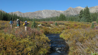 But those low bushes and grasses are actually waist high andvery dense, with marshy spots you might not see before splashing into them withboth feet. We began following apromising trail that ultimately meandered all around until we concluded that itwas an animal trail, not a people trail. There was no straight route across the meadow. We pretended to be Moses and the chosen peoplewandering in the wilderness. In spite ofthe slow process, I really enjoyed this interlude. The terrain was flat, the colors werespectacular and I had that feeling of a very small being in God’s great bigworld.
 Next we passed another small pond and walked through anarrow meadow still partially in shadow with lovely frost patterns.
 Frosty morning
 Jeff’s photo
 Couldn’t resist this tiny Christmas tree with a sunbeamspotlight
 When we reached the CDT we turned right for a couple ofmiles of pure delight, a rockin’ and rollin’ level trail through Longs Gulch,and then entered Holy Cross Wilderness.
 Long Gulch (Jeff’s photo)
 Another pretty pond
Our biggest climb of the day tested my lung capacity yetagain, 35 minutes of steepness, and I persevered (very) slowly and steadily butwithout stopping. I was still not lovingthe climbs but I was conquering them.
 At the top of the climb we reached the pass between GalenaMountain and an unnamed peak that Jeff wanted to bag. There were two beautiful small unnamed lakesto explore. But first…time forrefueling. What a spectacular settingfor lunch!
 Horses passing through to pick up a crew of fishermen who werecamping out at the lake.
 Cathy and I explored a little bit over the next ridge – a viewof everything coming up, snowy peaks and yellow aspens.
 The peak Jeff bagged today (Point 11,820).
During our rest stop Mike gave Cathy and me a tutorial onreading topo lines on a map, helping us understand what was ahead (some up,some down, surprise!). When Jeffreturned, we got back on the CDT.
 Across this open pass we had our best view of the day. At this point Jeff and Cathy were ahead andMike wasn’t sure if he had told them the next stopping point. Mike wanted to depart from the trail againand try a different route for the final approach to Uncle Bud’s Hut. He decided that they would figure it out forthemselves (Jeff had the GPS track) and so he stepped off the CDT in search ofthis alternate route, an old road. Ifollowed Mike – I wasn’t about to get left behind anywhere.
 We found the old road that Mike remember- ed and it took usabout a mile down to Uncle Bud’s. Jeffand Cathy were already there. And ourWashington, D.C. hut buddies evidently had made it there the day before becausethey left us a note and some marshmallows!
 Welcome to Uncle Bud’s Hut
 Once again we are the only residents
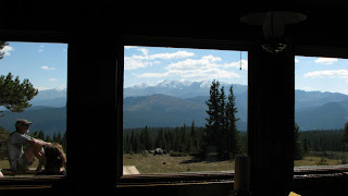
 We sat on the deck soaking up sunshine for a couple of hoursand admiring the front row view of Mount Elbert and Mount Massive
 Cathy is trying to relax (and succeeding)
 Mike
Mike
 Cathy toasting some bread for dinner
 Another gourmet feast: spinach and cheese tortellini, the last pound of Jeff’s frozen peas,chopped up pepperoni and sausage. Believe it or not, we actually had leftoverstonight that will reappear tomorrow night.
 Sitting at the front windows, we watched until the lightfaded to almost full dark before turning on lights inside. We sat and talked and read aloud a couple oftales from a book of local stories. Before bedtime we went back out on the deck to gaze at the sky full oftwinkling stars and the Milky Way arcing over our heads. Sigh… I wish everyone could have these kindsof experiences.
“He climbed cathedral mountainsHe saw silver clouds belowHe saw everything as far as he could see…Rocky Mountain High”~John Denver
Colorado Hut-to-Hut Adventure – Day 6 – 9/13/12 – Hiking toUncle Bud’s Hut – 11 Miles
Another Tylenol PM night with a different result – noheadache this morning! And a good thingbecause today was going to be our longest hike, going from 10thMountain Hut to Uncle Bud’s Hut via a hybrid route of cross-country ski trailsand the CDT (which still runs concurrently with the Colorado Trail). What will this be like? A great deal of variety in topography andlandscape and challenges – a terrific day.
Yesterday’s precipitation left a light frosteverywhere. This bench bears a plaque namingit “Catherine’s Bench”, in memory of a 29-year-old woman who loved hiking andskiing in the Colorado Mountains. Shewas killed by a lightning strike while hiking up one of the 14er’s. Her family installed a “Catherine’s Bench” ateach of the 10th Mountain huts. Say goodbye to 10th Mountain HutBuebird skies and 28 degrees. Ready for whatever comes next (Jeff’s photo)The first couple of miles consisted of backtracking, withCathy and me in front as route finders searching for those blue diamond trailmarkers (Cathy says “Blue diamonds are a girl’s best friend”).
A giant landmark that we remembered Clouds in the valley where the town of Leadville sitsA day of “reflection”We crossed the intersection with West Tennessee Lakes Trailand continued on the cross-country ski route, increasingly confident of ournavigational skills until we came to a very large meadow. I’m sure in winter it’s pretty simple to lookacross a white expanse the length of a football field and spot a 10-inch bluediamond nailed 25 feet up on an evergreen tree…but not today. We needed to cross the meadow and then scoutalong the tree line to find a trail marker. Looks simple enough, right?
But those low bushes and grasses are actually waist high andvery dense, with marshy spots you might not see before splashing into them withboth feet. We began following apromising trail that ultimately meandered all around until we concluded that itwas an animal trail, not a people trail. There was no straight route across the meadow. We pretended to be Moses and the chosen peoplewandering in the wilderness. In spite ofthe slow process, I really enjoyed this interlude. The terrain was flat, the colors werespectacular and I had that feeling of a very small being in God’s great bigworld. Next we passed another small pond and walked through anarrow meadow still partially in shadow with lovely frost patterns. Frosty morningJeff’s photo Couldn’t resist this tiny Christmas tree with a sunbeamspotlightWhen we reached the CDT we turned right for a couple ofmiles of pure delight, a rockin’ and rollin’ level trail through Longs Gulch,and then entered Holy Cross Wilderness.Long Gulch (Jeff’s photo)Another pretty pondOur biggest climb of the day tested my lung capacity yetagain, 35 minutes of steepness, and I persevered (very) slowly and steadily butwithout stopping. I was still not lovingthe climbs but I was conquering them.
At the top of the climb we reached the pass between GalenaMountain and an unnamed peak that Jeff wanted to bag. There were two beautiful small unnamed lakesto explore. But first…time forrefueling. What a spectacular settingfor lunch!Horses passing through to pick up a crew of fishermen who werecamping out at the lake.Cathy and I explored a little bit over the next ridge – a viewof everything coming up, snowy peaks and yellow aspens.The peak Jeff bagged today (Point 11,820).During our rest stop Mike gave Cathy and me a tutorial onreading topo lines on a map, helping us understand what was ahead (some up,some down, surprise!). When Jeffreturned, we got back on the CDT.
Across this open pass we had our best view of the day. At this point Jeff and Cathy were ahead andMike wasn’t sure if he had told them the next stopping point. Mike wanted to depart from the trail againand try a different route for the final approach to Uncle Bud’s Hut. He decided that they would figure it out forthemselves (Jeff had the GPS track) and so he stepped off the CDT in search ofthis alternate route, an old road. Ifollowed Mike – I wasn’t about to get left behind anywhere. We found the old road that Mike remember- ed and it took usabout a mile down to Uncle Bud’s. Jeffand Cathy were already there. And ourWashington, D.C. hut buddies evidently had made it there the day before becausethey left us a note and some marshmallows!Welcome to Uncle Bud’s HutOnce again we are the only residentsWe sat on the deck soaking up sunshine for a couple of hoursand admiring the front row view of Mount Elbert and Mount MassiveCathy is trying to relax (and succeeding)MikeCathy toasting some bread for dinnerAnother gourmet feast: spinach and cheese tortellini, the last pound of Jeff’s frozen peas,chopped up pepperoni and sausage. Believe it or not, we actually had leftoverstonight that will reappear tomorrow night.Sitting at the front windows, we watched until the lightfaded to almost full dark before turning on lights inside. We sat and talked and read aloud a couple oftales from a book of local stories. Before bedtime we went back out on the deck to gaze at the sky full oftwinkling stars and the Milky Way arcing over our heads. Sigh… I wish everyone could have these kindsof experiences. “He climbed cathedral mountainsHe saw silver clouds belowHe saw everything as far as he could see…Rocky Mountain High”~John Denver
Kaydol:
Kayıtlar (Atom)