Shining Rock SB6K Summit – 5/19/12 – Old Butt Knob Trail/ArtLoeb Trail/Greasy Cove Trail – 13+ Miles – 3600’ elev gain
Steadily chipping away at this SB6K hiking challenge. I am becoming more and more enamored of theMiddle Prong and Shining Rock Wildernesses on the Blue Ridge Parkway in westernNorth Carolina, where a bunch of these SB6K peaks hang out. For all the time I’ve been hiking, I’ve neverbeen to see the namesake of Shining Rock. Well, the time is now. Get ready - this may be my longest, most photo-filled post ever.
 I met my hiking good-luck charm, Jeff, and his friend Sharonon a beautiful Saturday morning at our usual meeting spot. Sharon is also a young’un like Jeff, but I toldhim that he would have to find another way to distinguish us than “old” Sharonand “young” Sharon. All day long he struggledas we both answered whenever he spoke. Idon’t think he found an equitable way to address us.
 Jeff promised a strenuous summit (always go for the mostelevation gain, right?) so we started from the Big East Fork parking area offHighway 276. Immediately after we gotout of my car we were approached by three large unleashed dogs, begging forfood. They did not seem to hear theirowners who were lamely calling them. Welcometo the wilderness, kind of the wild west of the outdoors, where everybody doeswhatever they want. Some even follow therules.
By 10:30 a.m. we started on Shining Creek Trail. I forgot my map, but Jeff let me carry hisbecause it’s my security blanket and he has his GPS. One of my goals for the day was to get betteroriented via the map, since these wilderness areas are not signed orblazed.
This is exactly where Jim and I got lost about eight yearsago trying to do a “quick” hike to Shining Rock before one of our kids’ bandcompetitions at Western Carolina University. Using a guidebook and no other map, we quickly got confused with all thesocial trails running to campsites along Shining Creek and had to abandon theplan. We experienced that, “Oh, crap,which way did we come” feeling for a few minutes when we decided to turnback. Now I am a little better atreading the trail but not enough to feel comfortable yet out here by myself.
For instance, at an early junction the left trail (very wideand obviously heavily used) was blocked by a large log. Back then I’m sure we stepped over the logwithout noticing it and hiked merrily on to campsites near the creek. Now I know that a big log or pile of branchesacross a trail means “you probably don’t mean to go this way if you’re passingthrough.” And when the Old Butt KnobTrail appeared on the right (no sign) today, I still would have likely missedit if Jeff hadn’t steered us to the turn.
 Old Butt Knob Trail is well named. It is extremely steep with sustained steppingup on boulders and climbing up Chestnut Ridge. My poor old butt got a workout. And yet…we were in Shining Rock Wilderness on a spectacular spring dayand life was very good.
  Mountain laurel bloomed profusely from the get-go
 A few steps on a side trail to the left gave long rangeviews of what was coming up, plus a moment to catch our breath and grab a snack. I’m looking at the long stretch of RavenCliff Ridge.
 Brave mountain laurel growing in the rock
 Jeff doing the limbo
 Purple and pink rhododendron began to appear overhead and only gotbetter as we continued the climb. Getready for the rhodo show!
 Thank you, sir, may I have another?
 And another
 And another
  Up close and eye level for Sharon Appell
 Surprise - a white flame azalea
Nearly everyone wesaw today had a dog, often more than one, some tiny ones on leashes or being carried, and German shepherds were favorites. We passed onebackpacker who actually had bear bells tinkling and two German Shepherds –protection against bears, I guess.
 Painted trillium
 Wood betony
 And how did this rock get split so evenly?
 I love how every high and low point has a name out in thewild. After all, that’s how the folksfrom yesteryear kept track of their world. After going over Old Butt Knob, we passed through Spanish Oak Gap, climbedsome more up over Dog Loser Knob, hiked down again through Beech Spring Gap,then finally found one of the summit trails to Shining Rock (once again Jeffhad to lead us, I wouldn’t have seen it on my own). This is Jeff and Sharon on the summit trailcutting through shoulder high blueberry bushes.
 Another SB6K summit!
 The white quartz is cold and slippery
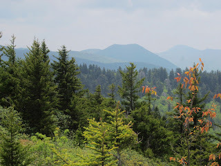 My favorite: Sam Knobfrom the summit of Shining Rock
After the summit, Jeff and Sharon and I continued on OldButt Knob Trail, passing multiple side trails presumably all going to ShiningRock. Really, how many people get losthere every weekend? We passed througha big camping area on the trail, filled with a Boy Scout troop with lots ofequipment.
Onward to Shining Rock Gap, where I have been before on ourhike to Cold Mountain. Five or sixtrails come together here with no signs. I spent a few minutes with our map and Jeff’s GPS, trying to get orientedto the intersection. To continue ourloop route we turned left onto Art Loeb Trail, mostly out in the open. We passed the Shining Creek Trail coming infrom the left, which is a few hundred feet from the big intersection, althoughon the map it looks like it’s part of the intersection. JeezLouise, I think I need to be led here a couple more times before I can feelconfident alone.
 Flower Gap, looking up at Flower Knob on the left and anotherbig ol’ big Boy Scout troop camp setup. Nice for them, kinda spoils the view for the rest of us.
  Just pretty to look at
After a mile or so of open rolling terrain we arrived at the sidetrail to Grassy Cove Top, an SB6K peak that Jeff and I have already done. We hinted that Sharon might want to do thislittle side jaunt in case she ever felt enticed to do the challenge, so up wewent.
Next Jeff showed us a shortcut to reach Grassy Cove Trail(aka Greasy Cove Trail – some people can’t spell), cutting out about a mile ofour loop. The time was getting away fromus because of our (my?) slow ascent. Jeffsays Grassy Cove is one of his favorite trails, lots of…grassy areas. It really is very nice, some great tucked away campsites…but no water. Gotta plan ahead.
 Pretty flowers I have not yet identified (note: I think this is Clinton's lily.)
The downhill was steep in places, knees and feet taking apounding. Sharon thought she had astress fracture in her foot that was giving her trouble. A few weeks ago I pulled the top part of myhamstring and it was making me cringe. The walking wounded.
On Greasy Cove Trail we ran into three backpacker guys collectingwater at a small spring. They asked uswhere they were. They were aiming forShining Rock and had taken verbal directions from someone to “turn right” at acertain spot, but apparently turned right way too soon. I asked if they had a map and one guysheepishly shook his head and said no. (Cue judgmental thoughts about people who go into a wilderness area without amap - look how nervous I am even with one.) Jeff gave them simple basic adviceto turn around and go back to the top of the trail and a left turn would takethem back out. I suggested that they askevery person they meet from now on to help verify where they are. They seemed properly equipped for anovernight trip except for not knowing how to navigate.
 Our biggest water crossing of the day was at Greasy CoveProng, a careful rock hop. Jeff and Sharon used my hiking poles. They don’t use poles because they are youngand invincible, but they didn’t say no when I offered them to get across thecreek.
  Greasy/ Grassy Cove Creek
 Zen
Zen Vasey’s Trillium – bloom nodding beneath the leaves
 Not to be confused with wakerobin – bloom standing above theleaves
Soon we reached the crossing for East Fork of the PigeonRiver at its confluence with Greasy Cove Prong, and on the other side was a campsite and aright turn onto Big East Fork Trail (this water was wider than the lastcrossing but with easy rocks to walk across). Now we were following the East Fork, big water, lots of cascades,teasing glimpses of whitewater throughthe trees, and a couple of times the trail dipped down to the water’s edge. The time was getting late and we did not feellike we had the luxury to take side trails down to the water. I really must explore this trail again.
 A parting look at the East Fork
Like most hikes, this one seemed to go on a little too long,but we were back at the car at 6:45 p.m., a little more than 8 hours for thisstrenuous hike, including two food breaks and lots of photos. We hiked a total of 13 miles with 3,600 feetof elevation gain. All in all, aterrific day in the North Carolina mountains.
“Walk as if you arekissing the Earth with your feet.” ~ Thich Nhat Hanh
Hiç yorum yok:
Yorum Gönder